Historical Architecture of Grosse Pointe – The Story of Fox Creek
Last week we presented the history of the Detroit Garden Center’s Garden Pilgrimage Tour, an annual event that began around 1935. Magnificent gardens around Metro Detroit were part of the program including a significant number in Grosse Pointe.
This week we stay with the theme of outdoor spaces as we head to Fox Creek to share the story of this historic area and the project that is currently underway to improve the space where the historic marker is located with new landscaping after it had become terribly overgrown.
The Fox Creek
The area known as Fox Creek is situated close to Windmill Pointe. The creek helps connect the area in Grosse Pointe Park with the Milk River in Grosse Pointe Shores via the Black Marsh Ditch that extends for miles (originally backed by a large, wooded marsh). The southern part of the ditch flows into Fox Creek then into the Detroit River by Alter Road, while the northern most point of the ditch is connected to the Milk River that empties into Lake St. Clair in the vicinity of Gaulker Pointe in Grosse Pointe Shores (close to the Ford Estate at 1100 Lake Shore). It is alleged “in the early days the Indians were able to use the two creeks and the marsh as a passage in times of high water, via a canoe route which enabled them to avoid rough water on Lake Saint Claire.” It is reported Wayne County dug the Black Marsh Ditch around 1885. Source: Grosse Pointe News (June 2005).
Windmill Pointe (in Grosse Pointe Park) is situated at the entrance of the Detroit River, east of the original mouth of Fox Creek. In the early 18th Century, a windmill was built on a high point of land just east of the peninsula. We understand Windmill Pointe was originally known by the French as ‘Presqu’ile’ (pronounced Pres’Kil), meaning a peninsula, while Fox Creek was called ‘LaCoulee des Renard’. Based on research in a document entitled ‘Grosse Pointe on Lake Sainte Claire (published by SILAS FARMER & CO.), we understand “the little stream called Fox Creek took its name, some say, from the number of foxes found in the vicinity.” However, it is suggested “it is far more likely the name came from the Indian tribe defeated nearby, as a few survivors of the Fox Creek Massacre (in 1712) are said to have followed its banks and escaped through the woods and the marsh at the rear”.
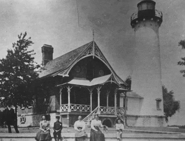
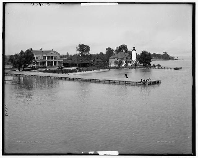
The Windmill Pointe peninsula was where the original light house (constructed in 1837) was once located, on what was known in the early days as Presque Isle (Almost Island), an inland peninsula formed by Fox Creek. The image below shows the lighthouse and keeper’s residence in 1900 – courtesy of the Grosse Pointe Historical Society. The second image is courtesy of the Library of Congress (1900 – 1910).
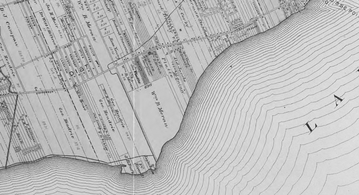
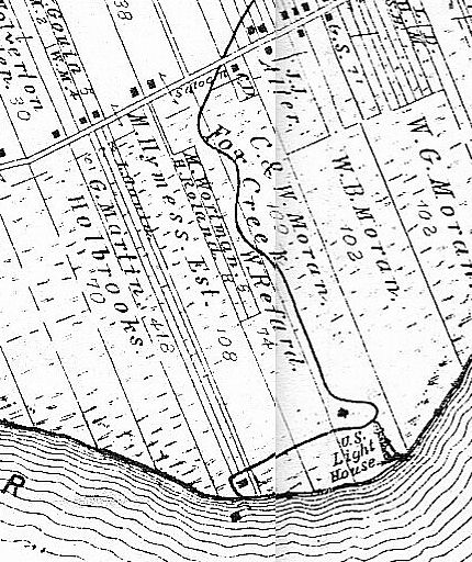
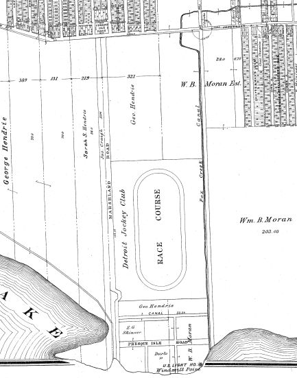
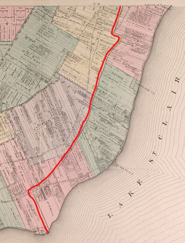
Over the years Fox Creek and the surrounding area has undergone numerous changes. During the early 1870’s, it is reported (on the website of the City of Grosse Pointe Woods), “local farmer William B. Moran took numerous samples around Grand Marais (“big marsh”) northeast of Fox Creek and found solid clay a few feet down. In 1874, he secured government help in draining the marsh south of Jefferson, a project which eventually made available some 900 acres of private lots. In 1876, Charles and William Moran each donated a strip of land to the government and “Lighthouse Road” (Alter Road) was cut through. Excess dirt was thrown up for dikes to make a new straight channel for Fox Creek.” The first image below is circa 1878, the second circa 1904. Images courtesy of: www.detroityes.com The third image shows the passage of the ditch (marked in red), as per a map circa 1893 (courtesy of Library of Congress).
In September 1924, it was reported “a number of citizens in the neighborhood of the lower part of the Creek took shovels and excavated the mouth of the stream. The men worked diligently and, in a few hours, had cut the sand bar that closed the mouth and threatened the existence of Fox Creek as a navigable stream. The owner of the land at the corner of the Creek and the Detroit River laid a technical claim to the sand bar that had filled in the entrance. The canal made by the enthusiastic diggers was just large enough to accommodate a small boat, making Fox Creek virtually a navigable stream, and presumably subject to Federal jurisdiction.” Source: Grosse Pointe Civic News (September 1924).
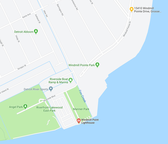
It is reported on detroitarchitectjournal.blogspot.com, “in 1925, the Fox Creek canal was constructed, running from the Detroit River to a point north of Jefferson Avenue where the canal now flows into underground pipes that run under Jefferson Avenue. It is alleged during prohibition, when Michigan became a primary entry of illegal alcohol, 75% of all illegal alcohol entering the US came through the state. It is also alleged the area along the Fox Creek Canal became one of many smuggling points.” (this cannot be verified). Today the canal and the creek still exist. Image courtesy of Google.com
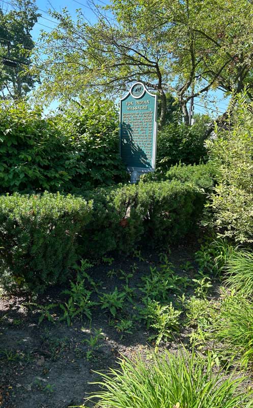
Fox Creek Massacre Historic Marker
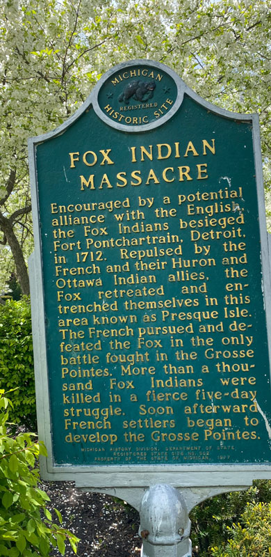
What makes Fox Creek so historic is that three hundred years ago, the first and only battle engaged in the Grosse Pointes occurred in the area. A historical marker commemorating the “Fox Indian Massacre” reads, “Encouraged by a potential alliance with the English, the Fox Indians besieged Fort Pontchartrain, Detroit, in 1712. Repulsed by the French and their Huron and Ottawa Indian allies, the Fox retreated and entrenched themselves in this area known as Presqu’ile Isle. The French pursued and defeated the Fox in the only battle fought in the Grosse Pointes. More than a thousand Fox Indians were killed in a fierce five-day struggle. Soon afterward French settlers began to develop the Grosse Pointes.”
The historic marker is at the intersection of Windmill Pointe Drive and Lakepointe Street (on the left) when traveling west on Windmill Pointe Drive. It was erected in 1997, by Michigan History Division, Department of State.
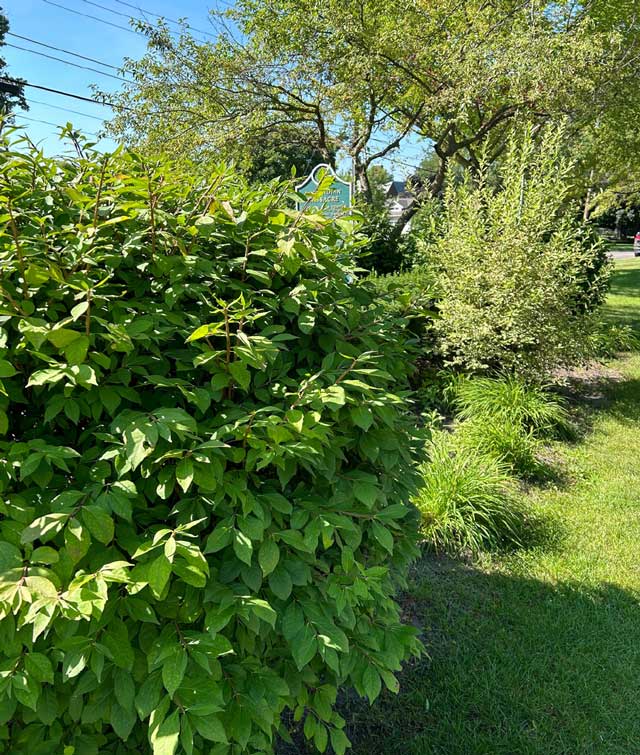
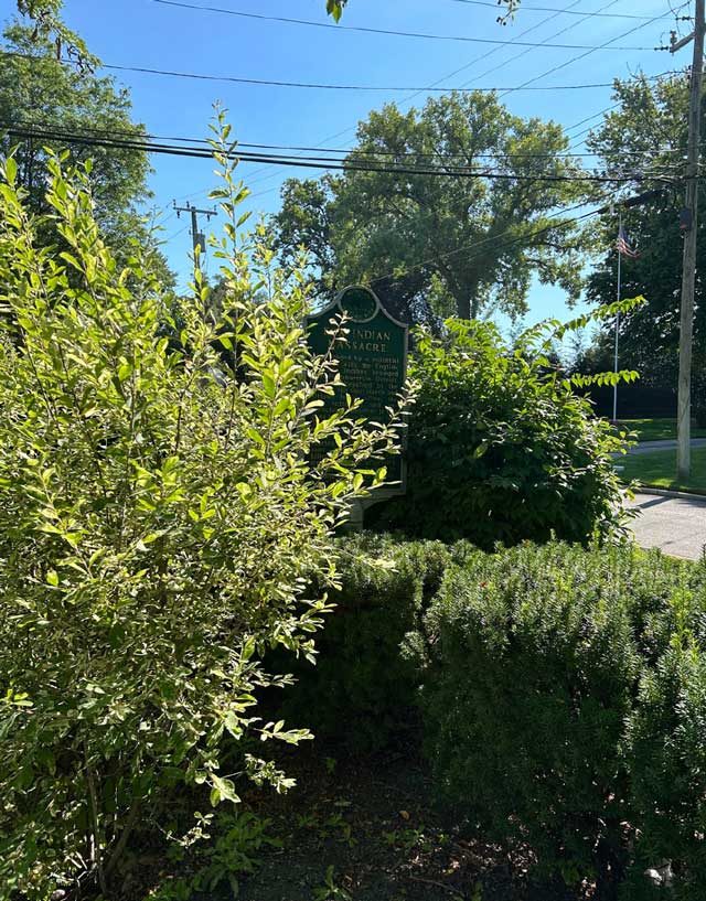
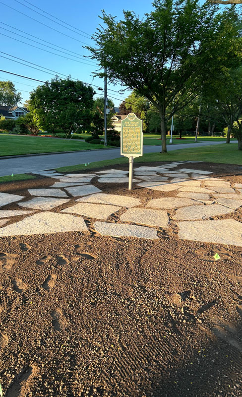
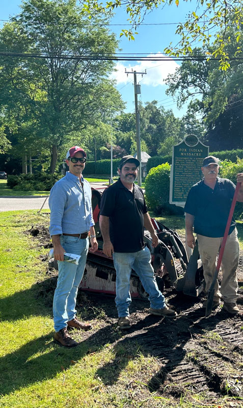
Over the years the landscaping has grown so high that the historic plaque is barely visible. Two trees, 15 bushes, and at least six plants surround the marker, installed on the median near the intersection of Lakepointe in 1977, by the Michigan Department of State’s history division. The area has always been blessed with a substantial amounts of forest trees; hickory, oak, elm, ash, beech, maple and poplar. Unfortunately, the landscaping has grown so high that you can hardly see the plaque. Given its importance, in 2024 it was decided to improve and restore the space. Photos (above and below) courtesy of: Grosse Pointe Park Foundation.
The Fox Indian Massacre Project is a collaborative effort run by the Grosse Pointe Park Foundation. The initiative is currently underway with the help of several organizations, including the Grosse Pointe Park Beautification Commission and the Junior League of Detroit. Phillip Morici, Co-owner FleurDetroit, project visionary and Grosse Pointe Park resident recently expressed how he hoped the newly designed space would allow people of our community and others to reflect on the many layers of said history. If you would like to learn more about the Fox Indian Massacre Project, please click here. The story of Fox Creek is historic and intriguing – one that should never be forgotten.
*Photos courtesy of the Higbie Maxon Agney archives unless stated.
** Research, information, and data sources are deemed reliable, but accuracy cannot be fully guaranteed.
Written by Katie Doelle
Copyright © 2024 Katie Doelle


